Aghdara district is an administrative-territorial unit in the Republic of Azerbaijan. The center is the city of Aghdara. The area is 1,150 km², and its recorded population is 12,100 (as of April 1, 2024). It was part of the Nagorno-Karabakh Autonomous Region (NKAR), established during the Soviet era and abolished after Azerbaijan gained independence. The district was abolished on October 13, 1992, by Decision No. 327 of the Milli Majlis (Parliament) of the Republic of Azerbaijan. The draft law on the re-establishment of the district was submitted to the Milli Majlis in 2023. On December 5, 2023, it was separated and became an independent district again. On November 26, 1991, the administrative-territorial unit of the Nagorno-Karabakh Autonomous Region was abolished by the law of the Supreme Council of the Republic of Azerbaijan. According to law, the name of Mardakert district was changed to Aghdara district, and it was included in the list of districts of republican subordination.
On July 7, 1993, the Armenians occupied Aghdara district and its villages, located 62 kilometers north of Khankendi, which was also one of the five administrative districts of the former Nagorno-Karabakh Autonomous Region. Before the occupation, more than 14,000 Azerbaijanis lived in 14 villages of Aghdara (Sirkhavand, Bashirlar, Garashlar, Garalar, Bash Guneypaya, Orta Guney, Khatinbeyli, Manikli, Tellibina, Narinjlar, Charaktar, Imarat-Garvand, Umudlu, Yeni Garalar) and the Ganjkhana state farm settlement. During the occupation, the entire population of the district was forcefully displaced from their native lands and settled in various regions of Azerbaijan. As a result of counter-terrorism measures carried out by the Armed Forces of Azerbaijan on September 19-20, 2023, Aghdara was returned to Azerbaijan. President Ilham Aliyev raised the National Flag of Azerbaijan in the city of Aghdara on October 15, 2023.
According to the Classification of Administrative Territorial Units, the liberated Aghdara district currently includes 1 city, 1 settlement, and 57 villages. The district consists of the city of Aghdara, the Shikharkh settlement, and the villages of Aghabayyali, Ashaghi Oratagh, Demirli, Gasapet, Bash Guneypaya, Janyatag, Gulyatag, Chardagli, Lulasaz, Megrelalay, Chayli, Sugovushan, Tapakand, Charaktar, Childiran, Davadashi, Mehmana, Dovshanli, Bazarkand, Hayad, Heyvali, Yayiji, Hasangaya, Chilaburt, Goyarkh, Maralyansarov, Hasanriz, Khatinbeyli, Imarat Garvand, Chapar, Zardakhach, Kichik Garabey, Kolatagh, Damghali, Gizilgaya, Yukhari Oratagh, Giziloba, Seysulan, Yarimja, Gozlu, Gozlukorpu, Malikli, Gazanchi, Narinjlar, Orta Guneypaya, Sirkhavand, Balligaya, Bashirlar, Garashlar, Talish, Ulu Garabey, Umudlu, Zaylik, Vangli, Chormanli, Shahmansurlu, Yeni Garalar.
Holy Elysee Temple Complex
Holy Elysee Temple complex is a historical-architectural site located at the foot of the Murovdagh mountain, between the villages of Sugovushan and Tapakand in the Aghdara district. The construction of the earliest buildings within the complex is associated with Vachagan III the Pious, the ruler of Caucasian Albania from the Arshakis dynasty. The temple complex is situated in a mountainous area with a rugged relief. The hill where the temple is located is surrounded by steep cliffs and dense forests, making access to the site difficult. The southern side of the hill, where the complex is situated, forms a vertical rock face, while strong fortress walls encircle the other three sides of the hill. The complex includes a cathedral, seven chapels, an ancient cemetery, and other ruined buildings.
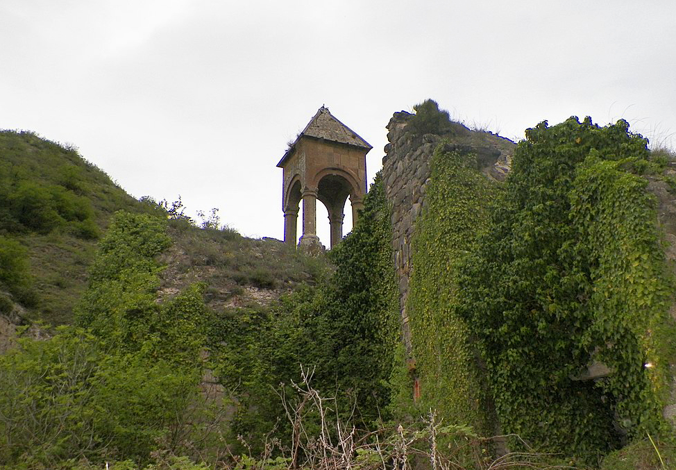
Great Aran/Monastery of Saint James

The Great Aran Monastery is located in a forested area on the right bank of the Khachinchay River, to the north of the village of Kolatagh. In historical literature, the monument is referred to as the Great Aran Monastery, named after the province in which it is situated. In medieval sources, this area was also known as Lower Khachen. The oldest inscription of the monastery dates back to the year 853. This inscription was written on a khachkar base, which was later reused during the construction of a wall. The Great Aran Monastery complex consists of two churches, two narthexes, and auxiliary structures such as residential buildings, all enclosed by fortress walls. All buildings are adjacent to each other and are mainly interconnected by passages. Inside the stone fortress walls are located a scriptorium where parchment manuscripts were stored, stone rooms with fireplaces, cells with balconies, a trapezoid-shaped kitchen building, a structure used for producing sesame oil, numerous storage buildings, a water reservoir, and guard posts. The khachkars, gravestones, cornices, arches, elevated altar platforms, door, window, and fireplace frames used in the construction of the buildings within the complex demonstrate the craftsmanship of medieval artisans. The first church located to the west of the monastery is known as the Church of Saint James. According to historical sources, the Church of Saint James was one of the sacred pilgrimage sites of Caucasian Albania. All of these buildings have reached our time in a semi-ruined condition. In 1836, under the insistence of the Gregorian Church, the Synod of the Russian Empire issued a decree abolishing the Albanian Church and transferring its authority to the Armenian Church. Following the cessation of the Albanian Church’s activities, all these churches were subjected to destruction and Armenianization.
The List of Immovable Historical and Cultural Monuments of National Importance
Architectural monuments
Name of the monument |
Construction date |
Location |
Temple |
19th c. |
On the shore of Aghoghlan river |
Mausoleum of Malikajdar |
14th c. |
Jijimli village |
Mausoleum |
17th-18th cc. |
Jijimli village |
Archaeological monuments
Name of the monument |
Construction date |
Location |
Stone box |
The Iron Age |
Abdallar village, between village and cemetery |
Barrow |
The Iron Age |
Jijimli village |
The List of Immovable Historical and Cultural Monuments of Local Importance
Architectural monuments
Name of the monument |
Construction date |
Location |
Spring |
|
Gushchu village |
Spring |
15th c. |
Gushchu village |
Behbudali spring |
15th c. |
Yaylaq Goybulag village |
Dashbulag spring |
17th c. |
Pirjahan village |
Dashbulag spring |
17th c. |
Sus village |
Dashbulag spring |
17th c. |
Seyidlar village |
Temple |
17th c. |
Hojaz village |
Bridge |
18th c. |
Bahala village, over the Hakari river |
Mausoleum |
|
Gulabird village |
Palace of Hamza Sultan |
1761 |
Husulu village |
Palace of Sultan Ahmad |
|
Soltanlar village |
Mausoleum of Soltan Baba |
19th c. |
Zeyva village |
Mausoleum of Sheykh Ahmad |
19th c. |
Zeyva village |
Mausoleum |
19th c. |
Zeyva village |
Kafir-Gala |
17th c. |
Zeyva village |
Mosque |
1718 |
Garigishlag village |
Fortress |
|
Garigishlag village |
“Damirovlu Pir” temple |
|
Garigishlag village |
Mosque |
|
Pichanis village |
Temple |
17th c. |
Pichanis village |
Mosque |
|
Pichanis village |
Temple |
12th c. |
Gorchu village |
Temple |
10th c. |
Ashaghi Farajan village |
Temple |
15th c. |
Shalva village |
Temple |
16th c. |
Ahmadli village |
“Aghbakht xeyir” mausoleum |
|
Ahmadli village |
Bridge |
19th c. |
Ahmadli village |
Temple |
15th c. |
Minkand village |
Temple |
15th c. |
Minkand village |
Two-arch bridge |
19th c. |
Minkand village |
One-arch bridge |
19th c. |
Minkand village |
Cave fortress |
15th c. |
Gulabird village |
Broken bridge |
|
Aghdara village |
Fortress |
19th c. |
Gushchu village |
Small fortress of Sadinlar |
|
Gushchu village |
Bridge |
19th c. |
Garagash village |
One-arch bridge |
19th c. |
Zabukh village |
Bridge |
19th c. |
Zabukh village |
Broken bridge |
19th c. |
Malkhalaf village |
Fortress |
|
Mirik village |
Temple |
15th c. |
Mirik village |
Bridge |
19th c. |
Pirjahan village |
Bridge |
|
Pirjahan village |
Bridge |
19th c. |
Seyidlar village |
Temple |
19th c. |
Sonasar village |
Bridge |
19th c. |
Sheytanli village |
Temple |
17th c. |
Sadinlar village |