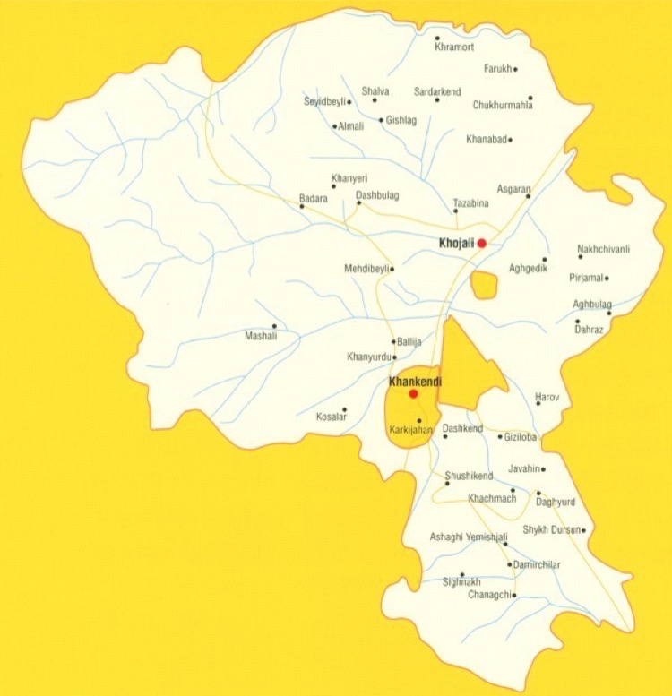
Khojaly district is the administrative district of the Republic of Azerbaijan. It is located on the north - eastern slope of the Karabakh Chain of Minor Caucasus. Its area is 940 km2; the population is 28,800 (01.01.2020). The central town is the city of Khojaly. The district's territory was occupied by the Armenian armed forces on February 26, 1992. The Azerbaijani army liberated 9 villages of Khojaly district on September 27-November 9, 2020.
The district covers the followings: Khojaly city, Askeran settlement and villages of Jamilli; Meshali; Dagyurd; Sayidbayli; Ballyja; Khanbaghi; Mehdibayli; Harov, Dagdagan; Dashbulag; Gahabashi, Badara; Khanezek; Sunjinka; Garabulag; Demirchiler; Madadkend; Gushchubaba; Gyzyloba; Hachmach; Ashaghi Yemishjan; Kosalar; Bashkend; Javadlar; Yaloba; Janhasan; Nakhchivanly; Pirjamal; Aranzamin; Agbulag; Dahraz; Tazabina; Sardarkend; Gyshlag; Khanabad; Aggadik; Gylychbag; Almaly; Garakotuk; Pirlar; Farrukh; Dashbashi; Chanagchy; Signag; Shushakend; Dashkend.
The following educational and social institutions were active before the occupation: 11 secondary schools 1 pre-school educational institution; children creativity center; 3 musical schools; Museum of Local History and Geography; 20 clubs, 29 libraries; central regional hospital; 13 medical assistance points and 4 outpatient treatment stations.
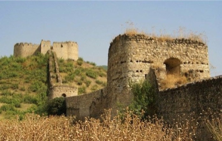
Following historic monuments existed in the territory of Khojaly district before the occupation: Askeran Fortress of 18th century; ancient monuments of architecture; octahedral domes and turbehs related to 13th-14th centuries; the compound of Khojaly monuments related mainly to late Bronze Age and early Iron Age (from 14th-13th centuries B.C. till 7th-6th centuries A.D.). These monuments are consisted of the following: 11 giant burial mounds in 5 different names; stone burial mounds; stone-land burial mounds; random bond buildings (called. in Azerbaijani as Galachalar); necropolises; menhirs (large upright standing stones weighing 5 -10 tons); stone sarcophaguses; stone tombstones and stone boxes.
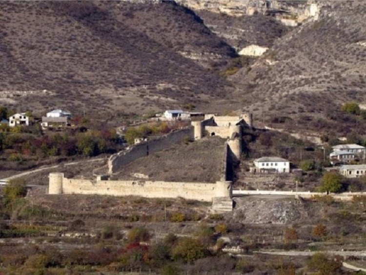
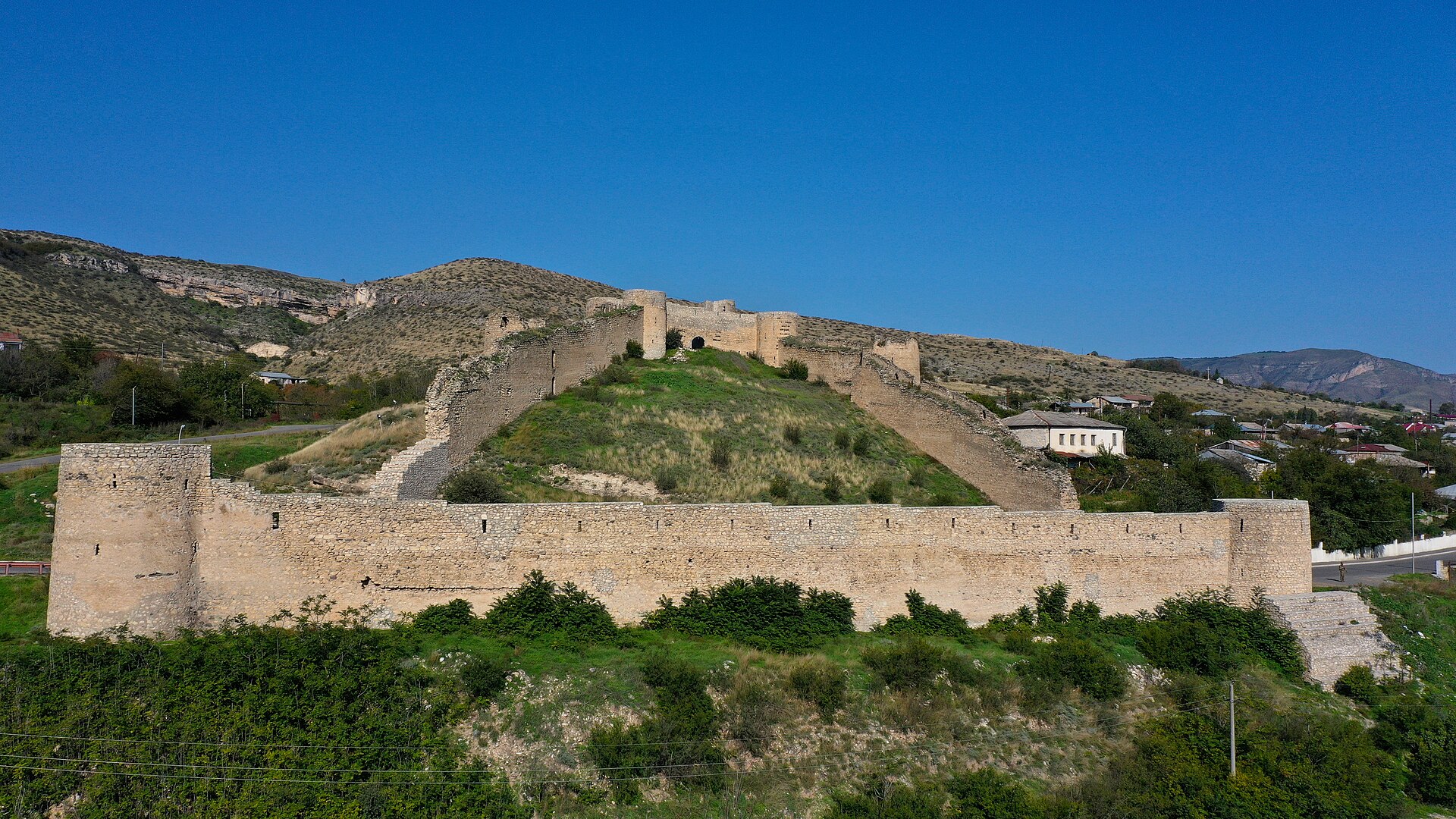
Asgaran castle
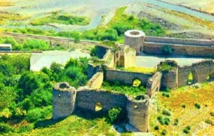
Located near Asgaran settlement of Khojaly district, 24 km from Shusha, Asgaran castle has a two-part structure harmonizing with the mountainous relief and the broad Gargar River’s bed.
Historian Mir Mehdi Khazani in his book “History of Garabakh” stated that raised by Ibrahim khan in 1787, this castle housed the infantry that had been called up to guard the capital of the khanate, Shusha city, against the attacks by the enemies from the East.
Due to its structure, Asgaran castle rather resembles a defensive barrier. It can be considered the last example of the century-old tradition of the Azerbaijan defensive barriers. Locating at the place with beautiful and unique landscape and integrating the heavy and entire volumes with the neighboring nature give an extremely magnificent appearance to the architecture of Asgaran castle.
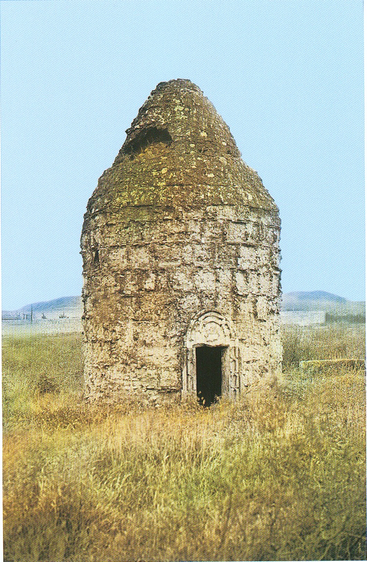
Khojaly Tomb
One of the monuments erected in the 14th century is Khojaly tomb built of the hewn white stones in Khojaly mound. Twelve angled structure of the monument and projecting entrance door with simple stone-carved ornaments significantly differ the Khojaly tomb from the other monuments of that period. As the stone coating of the Khojaly tomb peeled off, the monument had an unusual appearance.
Immovable historical and cultural monuments of state importance
ARCHITECTURAL MONUMENTS
Name of the monument |
Construction date |
Location |
Mausoleum |
14th c. |
Khojaly town |
Albanian temple |
1100 |
Chanakhchi village |
Albanian temple |
1065 |
Chanakhchi village |
Albanian temple |
905 |
Shushakand village |
Albanian temple |
1122 |
Khanyeri village |
Albanian temple |
1100 |
Khachmach village |
Albanian temple |
1202 |
Armudlu village |
Fortress |
10th c. |
Mashkhmaat village |
Fortress of Girkhlar |
Middle Ages |
Badara village |
Temple complex |
7th c. |
Badara village |
Fortress |
|
Dashbashi village |
Asgaran fortress |
18th c. |
Asgaran settlement |
Aslan fortress |
9th c. |
Anabert village |
Church |
13th c. |
Khanabad village |
ARCHAELOGICAL MONUMENTS
Name of the monument |
Construction date |
Location |
Stone box necropolis |
The Bronze Age |
Khojaly town, on the Askaran mountain |
Necropolis |
Early and Middle Bronze Age |
To the south from Khankandi |
Necropolis of vessel graves |
Early Middle Ages |
On the territory of Khankandi brick factory |
Barrow |
The Iron Age |
Near Khankandi |
Khankandi barrows |
The Bronze Age |
In the north of Khankandi |
Khachinchay barrows |
Early and Middle Bronze Age |
To the north-east from Seyidshan village |
Necropolis of vessel graves |
The Bronze Age |
Armudlu meadow |
Barrow |
The Bronze Age |
Armudlu meadow |
Stone box necropolis |
The Iron Age |
Armudlu meadow |
Old cemetery |
The Bronze Age |
Chanagchi village |
Stone box necropolis |
The Iron Age |
Daghyurd village |
Stone box necropolis |
The Iron Age |
Daghyurd village, on a slope of a mountain |